Our blog has now been incorporated into our main website! Although these posts will remain online for reference, please visit http://fths.org for new posts, event coverage and updated information.
Thank you!
Monday, December 3, 2012

Wednesday, October 31, 2012
Indiana Ghost Story
Since it's Halloween, here's a story from Evansville, Indiana to give you seasonally-appropriate goosebumps.
The Willard Library, a gorgeous piece of Gothic architecture, is the oldest public library building in Indiana. It's also rumored to be haunted -- and it seems someone caught the library's most famous ghost on camera. Click the link below if you want to see the pictures.
Wednesday, October 24, 2012
Acton UMC Craft Fair
It's once again time for the Acton United Methodist Church Craft Fair! Join us Saturday, November 3 at this annual fall festival. We'll have a booth with our publications (including Sylvia Henricks' latest book, Humble But Historic), memberships, and a few other items for sale. It's a great start to your holiday shopping!
The church is located at 5650 Senour Road, near the Acton Road exit off I-74. The craft fair runs from 9AM to 3PM. Food will be available onsite.
The church is located at 5650 Senour Road, near the Acton Road exit off I-74. The craft fair runs from 9AM to 3PM. Food will be available onsite.
Wednesday, October 10, 2012
Little Orphant Annie
It's almost Halloween, which means it's time to celebrate the most popular work of poet James Whitcomb Riley. Riley has no particular connection to Franklin Township, but he did grow up in nearby Greenfield, and he's one of Indiana's favorite native sons -- perhaps most favorite, if one judges by the number of things named after him.
As a seasonal treat (no trick!), here's one of the few surviving audio recordings of Riley reading his poetry aloud. This is "Little Orphant Annie," written by Riley in 1885. This (originally wax) recording was made in 1912, two years after the author suffered a stroke that left him partially paralyzed. Riley died four years later, in 1916.
 Anyone who grew up in Indiana schools probably had to memorize this poem -- or at least part of it -- in elementary school, where we also learned that the poem was intended to be called "Little Orphant Allie" (after Mary Alice "Allie" Smith, shown at right, who lived with the Riley family for a time). The published title was a result of a printing error (popularly attributed to Riley's bad handwriting).
The poem was one of Riley's best-known works. It was adapted as a silent film in 1918, and also served to inspire the "Little Orphan Annie" comic strip, which itself inspired books, movies and a major stage musical.
...And remember, if you want to hear more seasonal tales, join us on October 21 from 1 to 4 p.m. for Ghost Stories at Open Hours!
Tuesday, October 9, 2012
Report on September 16 Events
Today, we bring you one of Sylvia Henricks' "Remembrances." You can read more of Sylvia's columns weekly in The Franklin Township Informer, or in her book From The Ash Grove (available directly from the FTHS, and via the web site).
Will it rain – or be cold and windy? Are there seats enough out on the terrace at the Meeting House? Will anybody come? Will there be enough punch and cookies – or way too much? Where did I put the notes for the speech I plan to make, thanking those that let us photograph their WP Outhouses? Where’s my camera?
So ran my thoughts as Sunday afternoon, September 16 approached. The second half of a “double event” at the Township Historical Society it marked the completion of a self-published booklet, Humble but Historic, The Surviving WPA Outhouses of Franklin Township produced by Faulkenberg Printing, Indianapolis. I planned to autograph copies of the book for the invited guests – and others who might purchase one. (The other event, at 1:30, was a Big Run Cemetery Tour by Dana Crapo who has researched the early years of the cemetery when, privately owned, it was known as the Smither burial ground. See next week’s “Remembrances.”)
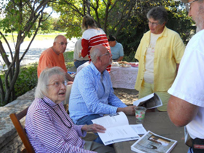
As often happens, my worries were needless. The weather was perfect, and a good crowd favored us. My daughter Ann and her three girls handled the punch and cookies, with more cookies supplied by Society members. Granddaughter Molly took photos including the one below.
There was an additional attraction on the Society grounds. With thanks to Yolanda Hughes, one-time owner, and Kathy George of Bob Cook Realtors – and Tommy Grimes, who moved it to our lawn—our Society is the proud owner of an authentic WPA outhouse, to be restored, repainted and valued as an exhibit of The Great Depression Days.
Will it rain – or be cold and windy? Are there seats enough out on the terrace at the Meeting House? Will anybody come? Will there be enough punch and cookies – or way too much? Where did I put the notes for the speech I plan to make, thanking those that let us photograph their WP Outhouses? Where’s my camera?
So ran my thoughts as Sunday afternoon, September 16 approached. The second half of a “double event” at the Township Historical Society it marked the completion of a self-published booklet, Humble but Historic, The Surviving WPA Outhouses of Franklin Township produced by Faulkenberg Printing, Indianapolis. I planned to autograph copies of the book for the invited guests – and others who might purchase one. (The other event, at 1:30, was a Big Run Cemetery Tour by Dana Crapo who has researched the early years of the cemetery when, privately owned, it was known as the Smither burial ground. See next week’s “Remembrances.”)
As often happens, my worries were needless. The weather was perfect, and a good crowd favored us. My daughter Ann and her three girls handled the punch and cookies, with more cookies supplied by Society members. Granddaughter Molly took photos including the one below.
There was an additional attraction on the Society grounds. With thanks to Yolanda Hughes, one-time owner, and Kathy George of Bob Cook Realtors – and Tommy Grimes, who moved it to our lawn—our Society is the proud owner of an authentic WPA outhouse, to be restored, repainted and valued as an exhibit of The Great Depression Days.

Monday, October 8, 2012
Ghost Stories - October 21
 It's coming up on Halloween, and that means it's the perfect time of year for ghost stories! Indiana has its fair share of paranormal oddities, and even Franklin Township has a few stories that just might make you shiver. Join us at Open Hours on October 21 for some chilling local legends and delightfully creepy tales from history. You can even see the infamous Black Dress, one of the stars of our collection, which has been featured on the TV shows Sightings and Unsolved Mysteries.
(Please note that this will be our final regular Open Hours of the year. You are still welcome to join us at any of the scheduled events during the off season, such as our Old Fashioned Christmas Celebration on December 16.)
Thursday, October 4, 2012
Remembrances: 1855 Township Map
Today, we bring you one of Sylvia Henricks' "Remembrances." You can read more of Sylvia's columns weekly in The Franklin Township Informer, or in her book From The Ash Grove (available directly from the FTHS, and via the web site).
 Old maps are fascinating to study, and are an almost endless source of speculation when compared with an area familiar to a reader today. Fellow historian Dana Crapo recently found and purchased the useful topographical map of the part of Franklin Township on Shelbyville Road we were wondering about. I used it several weeks ago in writing about the elevation of Scott and Mary Verbarg’s home in Franklin Parke Estates. Their hilltop site was designated as 900 feet above sea level, perhaps the highest spot in Franklin Township.
Another map that Dana recently purchased, and gave me copies of is an 1855 Franklin Township map, the earliest one I know of. I have had a copy of it for several years – Xeroxed myself at the Indiana State Library -- but Dana’s copies are sharp and bright, and show more clearly some early “roads” which were later abandoned. A portion of that map is shown above, with the land owner designated as Daniel Moore.
The Society’s Historic Treasures (1978) includes this information (in a longer biography) about Daniel Moore. “He was born in 1786 in Virginia . . .At age thirty he moved with his family to Kentucky. . . later they moved to Marion County, Indiana, locating on a farm nine miles southeast of Indianapolis. . . in what was then an unbroken wilderness, the family proceeded to make a home. The forest was cleared away and a fine farm developed . . . The Moore farm was in the family since 1835 when Daniel Moore received his land grant signed by Andrew Jackson. Their log cabin was built at Five Points and Stop 11 (although the roads were not so named at the time) where they owned additional land."
Our family’s six acres was not part of the Moore farm, but a parcel of the Nimrod Kemper farm to the south. Shelbyville Road cut through the corner of the Kemper farm as it did at another place the Moore farm. Our six acres includes a two acre field, and a wooded area which I was told was the woodlot for the Kemper farm across the road.When we first moved here I remember some “elderly “ ladies telling me they had picked wildflowers in our woods as children. Except for the field and a small area along Shelbyville Road, our land has never been farmed. We have three large ash trees, two beech trees, and an oak tree with a trunk 15 feet in circumference. Some large rocks in the yard are either remains of a glacier, or dug out of Kemper fields long ago.
 Old maps are fascinating to study, and are an almost endless source of speculation when compared with an area familiar to a reader today. Fellow historian Dana Crapo recently found and purchased the useful topographical map of the part of Franklin Township on Shelbyville Road we were wondering about. I used it several weeks ago in writing about the elevation of Scott and Mary Verbarg’s home in Franklin Parke Estates. Their hilltop site was designated as 900 feet above sea level, perhaps the highest spot in Franklin Township.
Another map that Dana recently purchased, and gave me copies of is an 1855 Franklin Township map, the earliest one I know of. I have had a copy of it for several years – Xeroxed myself at the Indiana State Library -- but Dana’s copies are sharp and bright, and show more clearly some early “roads” which were later abandoned. A portion of that map is shown above, with the land owner designated as Daniel Moore.
The Society’s Historic Treasures (1978) includes this information (in a longer biography) about Daniel Moore. “He was born in 1786 in Virginia . . .At age thirty he moved with his family to Kentucky. . . later they moved to Marion County, Indiana, locating on a farm nine miles southeast of Indianapolis. . . in what was then an unbroken wilderness, the family proceeded to make a home. The forest was cleared away and a fine farm developed . . . The Moore farm was in the family since 1835 when Daniel Moore received his land grant signed by Andrew Jackson. Their log cabin was built at Five Points and Stop 11 (although the roads were not so named at the time) where they owned additional land."
Our family’s six acres was not part of the Moore farm, but a parcel of the Nimrod Kemper farm to the south. Shelbyville Road cut through the corner of the Kemper farm as it did at another place the Moore farm. Our six acres includes a two acre field, and a wooded area which I was told was the woodlot for the Kemper farm across the road.When we first moved here I remember some “elderly “ ladies telling me they had picked wildflowers in our woods as children. Except for the field and a small area along Shelbyville Road, our land has never been farmed. We have three large ash trees, two beech trees, and an oak tree with a trunk 15 feet in circumference. Some large rocks in the yard are either remains of a glacier, or dug out of Kemper fields long ago.
Friday, September 28, 2012
Indiana trees
Today, we bring you one of Sylvia Henricks' "Remembrances." You can read more of Sylvia's columns weekly in The Franklin Township Informer, or in her book From The Ash Grove (available directly from the FTHS, and via the web site).
“A hundred years ago fully seven-eighths of the State of Indiana was covered with forests.” Since I’m quoting from a book (Indiana, a Guide to the Hoosier State, written in 1941), I had better make that “200 years ago”.
The early settlers were mostly farmers, hoping to make homes in which to raise and feed their families. They found their tracts of land covered with trees. Historians described the trees, growing so large and close together, that light could hardly reach the forest floor. Charles Deam in his Trees of Indiana (1931), reported 134 species, 124 native to Indiana, the other ten having been successfully introduced. Deam identified 17 species of oak, the black walnut and many species of maple tree. he also described “the beech, lovingly painted by Indiana artists for its mottled trunk and rich autumn colors, the massive sycamore, gleaming white along the banks of streams, and the majestic tulip tree, or yellow poplar, the State tree.”
But as beautiful as the trees were, the early settlers saw them not as adornment, but as something to be removed from the land, so that they could plant their crops. They spent much energy and time in clearing their farms. “Deadening” the trees was one method, removing the bark from an area surrounding the trunk, causing the tree to die. It was a slow process, but as the branches withered, light fell on the ground and made it possible to plow and plant underneath the tree.
“Log-rollings” were popular as community projects, where groups of men and women gathered. The men cut the trees down with their axes, cut and burned the underbrush, then chopped the trees into 10 to 20 foot lengths. These were piled up and burned. The women prepared a big meal to be enjoyed at the close of the day. Many of the best logs of oak, poplar, walnut and ash were left at the rollings to be split into rails for fences.
 But some trees survived the land-clearing, perhaps by their location in a farmyard or by their size or beauty. One such tree stands along Shelbyville Road on a curve near Edgewood Avenue. It is, I believe, a kind of oak tree (a chestnut oak?) for an acorn was forming in the clump of leaves we picked up. The leaves are oval in shape, not lobed as are the leaves of many oaks. I once asked a man standing by his mailbox across the road from the tree if it had a special history was a landmark, an early campsite, a boundary. No, he said, not that he knew of. ‘‘It’s just a big ole tree,” he said. If anyone knows more than that, please let me know.
“A hundred years ago fully seven-eighths of the State of Indiana was covered with forests.” Since I’m quoting from a book (Indiana, a Guide to the Hoosier State, written in 1941), I had better make that “200 years ago”.
The early settlers were mostly farmers, hoping to make homes in which to raise and feed their families. They found their tracts of land covered with trees. Historians described the trees, growing so large and close together, that light could hardly reach the forest floor. Charles Deam in his Trees of Indiana (1931), reported 134 species, 124 native to Indiana, the other ten having been successfully introduced. Deam identified 17 species of oak, the black walnut and many species of maple tree. he also described “the beech, lovingly painted by Indiana artists for its mottled trunk and rich autumn colors, the massive sycamore, gleaming white along the banks of streams, and the majestic tulip tree, or yellow poplar, the State tree.”
But as beautiful as the trees were, the early settlers saw them not as adornment, but as something to be removed from the land, so that they could plant their crops. They spent much energy and time in clearing their farms. “Deadening” the trees was one method, removing the bark from an area surrounding the trunk, causing the tree to die. It was a slow process, but as the branches withered, light fell on the ground and made it possible to plow and plant underneath the tree.
“Log-rollings” were popular as community projects, where groups of men and women gathered. The men cut the trees down with their axes, cut and burned the underbrush, then chopped the trees into 10 to 20 foot lengths. These were piled up and burned. The women prepared a big meal to be enjoyed at the close of the day. Many of the best logs of oak, poplar, walnut and ash were left at the rollings to be split into rails for fences.

Wednesday, September 26, 2012
Liberty Magazine, 1926
 Earlier this month, the Franklin Township Historical Society received a donation of antique books and magazines from board member Ben Schuman. One of these was an issue of Liberty magazine from May, 1926. You can view this and other magazines at the Meeting House, but here are some highlights!
Magazines in the early 20th century were a major media source for both news and entertainment. In 1926, radio broadcasting had only been in use for five or six years and was not yet ubiquitous, and the mysterious new technology known as "television" was still in development (the first experimental cathode ray tube was introduced about six months after this issue was published, but most Americans would not discover in-home television until after World War II). Magazines were large-format periodicals packed with articles, illustrations, news and fictional stories.
 Like modern magazines, periodicals relied heavily on advertising for revenue, and often sold full-page ads inside the front and back covers. This issue of Liberty features a full-page ad (at right) for a familiar product -- Lysol -- which was originally marketed for a very different use than the household cleaning products we know.
 Magazines also regularly featured serialized fiction, poetry and short stories. This suspense novella, Flying Death (at left) is very typical of the era. Before television or multiplex cinemas, reading fiction was one of the primary forms of entertainment, and escapist stories of romance and adventure were in particularly high demand. Many famous authors such as Charles Dickens, Arthur Conan Doyle, Johnston McCulley, Dashiell Hammett and Leslie Charteris established their writing careers by having their stories serialized in popular magazines.
 As we head into election season, we're reminded that some things don't change at all: Editorial cartoons and political satire have been published in periodicals for hundreds of years! Here are a few topical cartoons from 1926 (at right).
The Meeting House is open from 1 to 4PM on the first Saturday and third Sunday of each month from March through October. If you liked these photos, stop by and check out our collection of books, magazines newspapers and other vintage reading material!
Friday, September 21, 2012
WPA Outhouses: Humble But Historic
It might seem strange to write a book about outhouses -- those rustic shacks that our forebears used instead of the indoor porcelain plumbing we're used to -- but there is a lot of history in those little wooden buildings! During the Great Depression, the Works Progress Administration (WPA) and the Civilian Conservation Corps (CCC) were created to provide jobs for out-of-work citizens, and one of those unglamorous jobs was building outhouses. The Indiana Community Sanitation Program reported in January, 1943 that 125,791 “Sanitary Privies” had been built since the program began in December, 1933, providing more than $4 million dollars in WPA wages to otherwise-unemployed workers during the 1930s.

The stapled book was designed and printed by Faulkenberg Printing in Indianapolis. The Society has priced it at $7.00. You can purchase a copy in person at the Meeting House during Open Hours, or order one by mail via our website.
Wednesday, September 19, 2012
Shelbyville Road Farm History, part II
Today, we bring you one of Sylvia Henricks' "Remembrances." You can read more of Sylvia's columns weekly in The Franklin Township Informer, or in her book From The Ash Grove (available directly from the FTHS, and via the web site).
 The hilltop farm home of Christian and Sophia Klasing on Shelbyville Road, which I wrote about in the September 5 “Remembrances,” is shown in another, later photo (at left), which appeared in the Township Historical Society’s publication The History of Franklin Township Area Old Houses (1982). By then, Christian and Sophia were deceased, the brick house abandoned, and the property sold. The new owners would develop the farm during the next several years into Franklin Parke Estates. The hilltop site now holds two houses, one of them the home of Scott and Mary Verbarg, who are interested in the history of their property.
The hilltop remains. That there was a wide view from the hilltop was never in dispute. But just how high was the elevation? Historical Society member Dana Crapo solved the question, by going downtown to the State Office Building and -- in spite of parking difficulties, and confusion in locating the right office -- buying a topographical map of the area which includes that part of Shelbyville Road where the Klasing farm lay. The map, 22” by 27”, printed by the U.S. Department of the Interior, is a U.S. Geological Survey, covers “the Beech Grove quadrangle.”(Topography, 1966; Roads, 1998.)
The map does record the height of the hill on which the farm house stood, slightly north of Shelbyville Road, at 900 feet. My six acres next door to the Franklin Parke Estates, are shown with two tiny black squares (one the garage) close to Shelbyville Road, east and somewhat south of the hilltop as 870 feet. I was surprised at this, as I always thought we lived “down in a hollow.” The Society Meeting House is 843 feet.
Indiana, A Guide to the Hoosier State, (1941) states on p.7 “About two thirds of Indiana is prevailingly level or rolling, while a smaller portion, largely in the south, is hilly. The average altitude is 700 feet above sea level. The greatest height, 1,285 feet is in Randolph County, near the eastern border; the lowest point, 313 feet, is in Vanderburgh County on the Ohio River.
(To be continued in a future "Remembrances.")
Saturday, September 15, 2012
Got your FCHS yearbook?
 Hey, Franklin Central High School grads... It's Homecoming season! Do you need to brush up on the names of your classmates? Maybe pick up a few signatures that you missed way back when?
The Franklin Township Historical Society has a stash of vintage FCHS yearbooks for sale for just $20 each! We have most years in stock from 1951 through 1987. You can order them along with our other publications here, or email mlinne@hrtc.net to arrange to pick one up at the Meeting House.
Monday, September 10, 2012
Cemetery Talk September 16

While you're there, step across the street and visit our Meeting House during Open Hours, which last from 1 to 4 p.m.
Wednesday, August 29, 2012
Shelbyville Road Farm History, part I
Today, we bring you one of Sylvia Henricks' "Remembrances." You can read more of Sylvia's columns weekly in The Franklin Township Informer, or in her book From The Ash Grove (available directly from the FTHS, and via the web site).

Now, 30 years later, all is changed. The farm has been gone for a long time, and the fields around it turned into Franklin Parke Estates, with its streets winding across the one-time fields. The hilltop remains, but is now the site of two handsome homes.
The new owner of one of the houses, Scott Verbarg, having seen my photograph of “The Klasing Farm,” asked me if the Township Historical Society had any information on what is now his property. I said I’d see what I could find.
I have been able to find a few items of interest. In the Society’s publication Historic Treasures of Franklin Township (1978 ) is a paragraph on page72 by an unsigned contributor, “Klasing History.” “Christian Klasing and his wife, Sophie (Kirkoff), came to the U.S. from Germany as children near the middle of the 1800’s.
“They were married in Indianapolis and in 1884 bought their 140 acre farm located at 7245 Shelbyville Road, presently owned by Mr. and Mrs. Allen Cary. The farm was purchased for approximately $8000 from Fred (Butch) Miller who had cleared all except forty acres of the land and built all the buildings that now stand on the farm.
“William Klasing (92) is the only living survivor of five boys and three girls in the Christian Klasing family. William owns seventy acres of the land which his mother and father bought, located at 7448 E. Southport Road.” Property lines and acreage can be seen in Section 13 on the 1889 Franklin Township map, one of the Society’s publications.
(To be continued in a future "Remembrances")
Wednesday, August 22, 2012
Ice Cream Social at Meeting House
Today, we bring you one of Sylvia Henricks' "Remembrances." You can read more of Sylvia's columns weekly in The Franklin Township Informer, or in her book From The Ash Grove (available directly from the FTHS, and via the web site).
The Franklin Township Historical Society celebrated the cooler weather at its Open Hours on Sunday, August 19 with an Ice-cream Social on the grounds, and recognizing new members to the Society. The names of 27 new members and those renewing their first year memberships, were placed in an old-fashioned glass churn base, with a name to be drawn later in the afternoon. That person would receive one of the Society’s woven coverlets showing historic buildings in Franklin Township.
Twenty or so membes and guests enjoyed the frozen-yoghurt “ice-cream” with a variety of toppings, and cookies, served in the shade of the building by Program Chair, Diana Hipple and her committee. Other members and guests in the Meeting House looked at a genealogy chart for Sue Winton, including many generations, and several recent gifts to the Society. One of these was a large wooden wheel upon which the bell to the original New Bethel Baptist Church had been attached, the gift of Oren Schilling.
At the close of the afternoon the name of the lucky winner of the coverlet was drawn, new member Mary L. Lovell.
Those present were reminded of the Open Hours on Sunday, September 16, when Dana Crapo will give a Big Run Cemetery Tour. That afternoon will also include at its conclusion, a book signing session for the Societiy’s new publication, “Humble but Historic, the Surviving WPA Outhouses in Franklin Township, Marion County, Indiana”, by Sylvia. The owners of these structures, and those who helped with information will be recognized and presented with a book. The publication will then be “officially” on sale for $7.00. (Open Hours at the Meeting House are held on the first Saturday and the third Sunday of March through October, from 1 to 4 p.m.)

Members enjoying frozen yoghurt.

Winner of drawing for the woven coverlet, Mary L. Lovell, center. On left Diana Hipple, on
right, society president John Kanouse.
Wednesday, August 15, 2012
From The Ash Grove: Interurban
Today, we bring you one of Sylvia Henricks' "Remembrances." You can read more of Sylvia's columns weekly in The Franklin Township Informer, or in her book From The Ash Grove (available directly from the FTHS, and via the web site).
Written for my June 20, 1985, column for the Informer, “From the Ash Grove,” this glimpse of the past reminds us again of that wonderful transportation innovation, the Interurban.
Cousin Mary who lives in Acton has asked you, one of her city relations, out for the day. “Get an early car,” she said.
So you consult your Indianapolis and Cincinnati Traction Company Vest Pocket Time Table, and find you can get an interurban car at the traction terminal on Market Street at 7:30, 9:30 or 10:30 a.m. No.24, which leaves at 8:35 won’t do, for it is the Greensburg Express and stops only at Shelbyville and Greensburg.
No.4, leaving at 7:30 a.m. arrives at Five Points at 8:02, New Bethel at 8:08, and gets to Acton at 8:17. No.6 repeats that schedule two hours later. No.26, which leaves downtown at 10:30, is a Limited, which shaves seven minutes from the time by stopping on signal only at the stations, and reaches Acton at 11:10. The locals stop on signal at designated points all along their route. (Some interurban stops survive today in the names of our county roads, such as Stop 8, and Stop 11.) For after dark signals the timetable warns, “Use a Light.”
After a pleasant day with Cousin Mary, you can catch the 5:31, the 7:31, the 8:41, the 9:31, or the 11:31 car back to Indianapolis. No.19, the last car, reaches the downtown terminal at 12:10 a.m. Robert Paugh, Maze Road, gave the Historical Society a Xerox copy of the August 6, 1911 timetable, found in an old house by his daughter. A railroader himself, he worked for B.& O. for 36 years as a brakeman and conductor. His interest in railroading continues and he has “locks and keys, and a whole menagerie of stuff,” he says.
 He remembers only faintly seeing the big electric cars run through Acton, “down Main Street, we called it,” he says. (It’s now Swails St.) More clearly he remembers workmen taking up the iron rails in the 1930s when the interurbans were going out of business. Five other electric railway companies provided hourly service to “200 other stations in Indiana, including Fort Wayne, South Bend, Warsaw, Winona Lake, Michigan City and Laporte.”
On Jan. 1, 1900, the first interurban line entered Franklin Township along Southeastern Avenue. At Hickory Road it turned south and making a wide turn through the corner of a field, followed the railroad tracks past the Acton Camp Ground, into Acton. Just beyond Acton it again paralleled the railroad tracks on to Brookfield, London, Fairland and Shelbyville. The end of the era came in 1941 when the last car made its final run.
Wednesday, August 8, 2012
Vandergriff Road
Today, we bring you one of Sylvia Henricks' "Remembrances." You can read more of Sylvia's columns weekly in The Franklin Township Informer, or in her book From The Ash Grove (available directly from the FTHS, and via the web site).
Here is a final article on old roads in Franklin Township. In the northeast corner of the township is Vandergriff Road, which fits our description of “an early road” by its cross-country pattern. Unnamed, it connects Wanamaker with the east edge of the county as shown on the 1889 map of Franklin Township.
 Several years ago a woman called me to ask if “Vandergriff Road,” named on her more recent map, had any connection with Robert Louis Stevenson’s American wife, Fanny Vandergriff. I said, “None that I have ever heard of.” But I did become curious about the name. Recently I looked in the index of Sulgrove’s History of Indianapolis and Marion County (1884) to see if some early landowner was so named. I found several persons by that name, who had held political jobs, and one Civil War soldier, but none seemed to have any connection with Franklin Township.
And then I thought of our Society’s “Franklin Township Area Old Houses” published in 1982 (reprinted in 2003) written by Velma Ruede, and her committee (of which I was the photographer). The book includes more than 300 houses in Franklin Township, and adjoining townships. Velma did extensive research on early landholders, read many abstracts, and provided much genealogical material as well as historical information on the houses.
And there, on page28, was the information I was seeking. 11002 Vandergriff Road was the final entry of seven houses on the road. At that time, the property of Horace A. and Patricia (Cunningham) King, the entry began with “From the U.S.A. to Isaiah Bisbee 1821,” through 13 owners to William J. and Edith Cunningham 1935. At one point in the description of the ownerships, Velma included. “In 1913 the place went to Homer and Lydia Vandergriff, for whom the road was named.”
Thank You, Velma. Velma’s lifelong devotion to community history, her non-stop work ethic, her legacy of histories of Pleasant View, Moral Township, London, Brookfield and Fairland, and her memories of persons and events –all made her an unforgettable person herself. She died December 16, 2007 at 89, and we still miss her.
Wednesday, August 1, 2012
Marjorie Main at the Artcraft, August 24-25
For the third year in a row, the Historic Artcraft Theatre in Franklin, Indiana will be showing one of the classic Ma & Pa Kettle films starring Acton-born actress Marjorie Main (who also has a connection to Franklin, Indiana, having attended Franklin College) . Visit the Artcraft August 24 & 25 to see Ma & Pa Kettle Back On The Farm.
The Arcraft is a delightful history piece itself; built in 1922, it has operated as a vaudeville house and movie theatre, and is now owned by Franklin Heritage, Inc., an organization that promotes historic preservation. All proceeds from the films shown there fund the restoration of the theatre and adjacent historic properties.
Wednesday, July 25, 2012
William McGregor
Today, we bring you one of Sylvia Henricks' "Remembrances." You can read more of Sylvia's columns weekly in The Franklin Township Informer, or in her book From The Ash Grove (available directly from the FTHS, and via the web site).
We can be sure that a road of some kind, named or unnamed, ran in a westerly direction from Acton. We see it on early maps. The road or trail followed the creek (Wildcat Creek, on one map) staying on its north side. Then it cut in a northwesterly direction , perhaps through a wooded acres, to a point where it again went due west.
William McGregor, for whom the road was ultimately named, was not a pioneer settler of Acton. According to a brief biography of him, reprinted in the Society’s Historic Treasures (p.87), originally taken from “The People’s Guide, a business, political and religious directory of Marion County, Indiana, published in 1874,” he was born in 1828 near Madison, Indiana. His mother died early, and his father had trouble providing for the family. William and one of his brothers moved to Madison and learned the blacksmithing trade. William moved to Greenwood where he opened a shop. He added another fire in 1851, another in 1852, and a wagon shop. In 1858 he sold his shop at a profit and bought land in Missouri where he moved his family.
His daughter’s health caused him to return to Acton, where he bought a house and lot. He built a shop with five fires where he made plows, buggies and wagons, working five blacksmiths, seven woodworkmen, two painters and a trimmer.” William McGregor directed his prosperous business until 1866, then bought 88 acres of land from Joseph Fitzgerald for $84 an acre. He added several more parcels of land until in 1893 he owned 215 acres of which 150 were cleared. Mr. McGregor was a trustee of the Missionary Baptist Church.” The McGregors had nine children, two of whom died in infancy.
What a surprise it was several months ago when our Society received an email and a framed photo of the house from a woman who lives in Ames, Iowa. (I am quoting Marlena’s "Remembrances” of March 28, 2012.) “She had bought it at an estate sale among other items, and rather than give it to the Goodwill, she decided to contact us first. And we’re so glad she did! Of course, no one knows how the picture got to Ames in the first place. . . ” We wrote her, thanking her for the photo, which had arrived safely. It can be seen on display at the Meeting House.
According to the Society’s Franklin Township Area Old Houses (1982) p.67,the house is believed to have been built around 1887. Harold Mutz bought the property in 1954 and did extensive restoration, adding a family room and kitchen. Other previous renters or owners have been The Faulconers, Dore and Edith Nolting (1935-47, Littletons and Ralph Burge. Mr. Mutz sold it to Dr. Paul Walton, who has also made restorations.
Wednesday, July 18, 2012
McGregor Road
Today, we bring you one of Sylvia Henricks' "Remembrances." You can read more of Sylvia's columns weekly in The Franklin Township Informer, or in her book From The Ash Grove (available directly from the FTHS, and via the web site).
Another of the early roads in Franklin Township is what is now known as McGregor Road. If we consider “early roads” those that seem simply to have grown from use, perhaps animal trails through the woods or along streams, or paths from one place to another, there are three such roads in our township. Shelbyville Road, that winds its way into Indianapolis, McGregor Road, which connects the south-east corner of Franklin Township to the north-west corner by a long-ago path to we now call Churchman Avenue, and a third (or fourth) road might be Vandergriff Road which winds through the north east corner of the township to Wanamaker. These old roads are interesting to contemplate.
On old maps what we call McGregor Road is clearly shown, running west from Acton (or east to Acton) along the north bank of Wildcat Creek. It makes a turn or two, and heads for the present-day Historical Society Meeting House on Franklin Road. There at one time, it followed the north property line due west for a short distance, and then went cross-country through the Deerberg farm. (I once visited the family, and, as we talked, I asked how it happened they had built their house so far off a road. “Oh,” Mrs. Deerberg said, “but there was a road. It went right by our house. Part of it is still our lane to Stop Eight Road.” A couple other jogs and the old road appeared to connect to the south end of Churchman Avenue.
I called Max Bridgford of Acton to ask if he knew anything about the road, or an earlier name. “It’s been McGregor Road all my life,” he said. He told me the names of five famiilies that have lived on it. John Meyers, Bill Meadert, Jerry Rabourn, Dr. Walter Rubush,and “Mr. Nolting who lived in the McGregor House until Mr. Mutz bought it.” Max also told me that Acton Road was another road paved with cement, as was the Shelbyville road. He remembered how some farmers driving horse-drawn wagons had to use the berm, if the road was too slippery for horses.
I plan to write something about William McGregor next week, and use an early photograph of his home, which the Historical Society came by in an unusual way. I know nothing about Vandergriff Road, where it got its name, who built it, or how old it is. Any information would be welcome.

Another of the early roads in Franklin Township is what is now known as McGregor Road. If we consider “early roads” those that seem simply to have grown from use, perhaps animal trails through the woods or along streams, or paths from one place to another, there are three such roads in our township. Shelbyville Road, that winds its way into Indianapolis, McGregor Road, which connects the south-east corner of Franklin Township to the north-west corner by a long-ago path to we now call Churchman Avenue, and a third (or fourth) road might be Vandergriff Road which winds through the north east corner of the township to Wanamaker. These old roads are interesting to contemplate.
On old maps what we call McGregor Road is clearly shown, running west from Acton (or east to Acton) along the north bank of Wildcat Creek. It makes a turn or two, and heads for the present-day Historical Society Meeting House on Franklin Road. There at one time, it followed the north property line due west for a short distance, and then went cross-country through the Deerberg farm. (I once visited the family, and, as we talked, I asked how it happened they had built their house so far off a road. “Oh,” Mrs. Deerberg said, “but there was a road. It went right by our house. Part of it is still our lane to Stop Eight Road.” A couple other jogs and the old road appeared to connect to the south end of Churchman Avenue.
I called Max Bridgford of Acton to ask if he knew anything about the road, or an earlier name. “It’s been McGregor Road all my life,” he said. He told me the names of five famiilies that have lived on it. John Meyers, Bill Meadert, Jerry Rabourn, Dr. Walter Rubush,and “Mr. Nolting who lived in the McGregor House until Mr. Mutz bought it.” Max also told me that Acton Road was another road paved with cement, as was the Shelbyville road. He remembered how some farmers driving horse-drawn wagons had to use the berm, if the road was too slippery for horses.
I plan to write something about William McGregor next week, and use an early photograph of his home, which the Historical Society came by in an unusual way. I know nothing about Vandergriff Road, where it got its name, who built it, or how old it is. Any information would be welcome.

Map (1900?) shows McGregor road north of Wildcat Creek, going through Mr. McGregor’s properties. The road is not named on the map. It runs north of the town, crosses Buck Creek, and into Shelby County.
Subscribe to:
Posts (Atom)

